Maracay Maps and Orientation
(Maracay, Aragua, Venezuela)
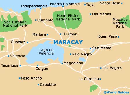
The city of Maracay lies along an indent on the shore of Lake Valencia, the third-largest freshwater lake in
Venezuela. Backing the city are the foothills of the central range of mountains. Those to the north separate the city from the coast, with some of the highest peaks in the country lying above the city.
Maracay stretches out along two valleys, together named the Central Valleys of Aragua province. The city is within a comfortable hour's drive of the capital city,
Caracas, and within easy reach of many of the natural attractions in the region, including the
Parque Nacional Henri Pittier, which begins at the outer edge of the city. Maps of the region and the rest of Venezuela can be found at the local tourist centres and tour company offices based around the Avenida de las Delicias.
Maps and Orientation of the City
Maracay's city centre is the oldest district and the home of most of the city's attractions. Its business and commercial centre is nearby, holding many of the better hotels, and as the city spreads out along the lakeshore, the industrial and residential areas take over. The Avenida de las Americas (Avenue of the Americas) - the massively long main road which runs the length of the continent, passes near Maracay.
The heart of the city comprises the Plaza Bolivar and its two main boulevards, the Avenida Bolivar and the Avenida de las Delicias. Most of the shopping malls lie in the centre, while the Air Force and army bases are set along the edge of the city. Maracay is also a university city, with a military university open to civilians. Close by is Valencia City, where the nearest airport is located.
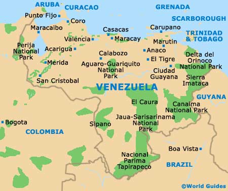
- Barquisimento - 203 km / 126 miles (two hours, west)
- Caracas - 72 km / 45 miles (one hour and 25 minutes, north-east)
- Colonia Tovar - 60 km / 37 miles (one hour and 20 minutes, north-east)
- Ciudad Ojeda - 419 km / 260 miles (three hours and 45 minutes, west)
- Cumana - 358 km / 222 miles (three hours and 15 minutes, north-west )
- Maracaibo - 456 km / 283 miles (four hours and ten minutes, west)
- San Cristobal - 598 km / 372 miles (five hours and 25 minutes, south-west)
- San Francisco de Yare - 102 km / 63 miles (two hours, east)
- San Mateo - 23 km / 14 miles (30 minutes, west)
- Valencia - 58 km / 36 miles (one hour and five minutes, west)
Map of Venezuela
Map of Maracay